
Descripción
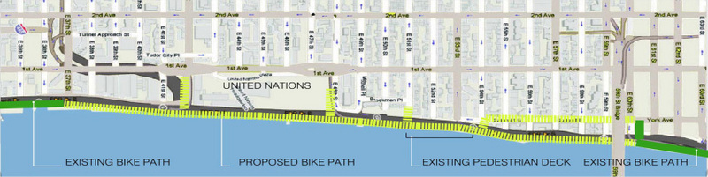
The Greenway is still incomplete from 41-60 streets on the East Side. 9 cyclists have been killed in 12 years (1995-2007). Close the Gap and save lives!
*** Update ***
The extension to Glick Park now extends the esplanade to 41 Street, or a bit beyond. The extension to Andrew Haswell Green Park on the northern end of the gap, will soon extend the esplanade south to 60th street. So, there are only 19 blocks left to Close The Gap!


61 Comentars
Scott Baker (Invitado)
Scott Baker (Invitado)
http://www.change.org/actions/view/close_the_gap_2
CT Livable Streets Campaign (Usuario registrado)
I often bike in NYC and have wanted this fixed for a long time. Please post updates on any progress here, so we can stay informed.
You can also forward this SeeClickFix page to the petition signers, and to neighborhood groups or elected officials in the area, inviting them to post comments and concerns.
Getting more votes, and sending this out to local bloggers is also a good way to raise the level of the concern and possibly get the newsmedia to write a piece on it. Let's raise the profile of this issue!
Scott Baker (Usuario registrado)
http://groups.google.com/group/TAEastSideCommittee?hl=en
and I have posted extensive documentation, as have some others, on the Gap and other issues related to getting bike lanes on the East Side.
The biggest contribution I have made is my 20 page photo-article: Closing the Gap (in .pdf), which documents, with lots of pics, the Gap, the alternate (and dangerous) route, the stats on bike fatalities from 1995-2007, and the proposed remedies to Close The Gap.
CT Livable Streets Campaign (Usuario registrado)
Scott Baker (Usuario registrado)
Check the TA site for more details, or the Google Group:
http://groups.google.com/group/TAEastSideCommittee
Scott Baker (Usuario registrado)
The State has given the city a deadline of 1/1/10 to use the caissons in the East River as part of the Esplanade, or LOSE them forever! Come and encourage the CBs to demand the Greenway be completed NOW, while we have this rare opportunity.
Scott Baker (Usuario registrado)
Scott Baker (Usuario registrado)
Scott Baker (Usuario registrado)
This just in from Metropolitan Waterfront Alliance:
- East Midtown Waterfront Park and Esplanade Manhattan Greenway, UN segment
The City's Small Business Services and EDC will advance planning and preliminary design for waterfront amenities along the East River
between East 38th Street and East 61st Street. When completed, the project will fill a major gap in the Manhattan Greenway, a 32-mile
waterfront path around Manhattan that remains disconnected in parts.
In this section, the FDR Drive and the United Nations campus block waterfront access.
* Total Project Cost: $800,000 Amount Awarded: $400,000
Also, somewhat related (note the location) is the following:
- East River Blueway Trail
The Manhattan Borough President will complete plans for the future Blueway Trail in the East River from East 38th Street to the Brooklyn
Bridge. Christine Datz-Romero, executive director of the Lower East Side Ecology Center, explained that the Blueway Trail will focus on
waterfront access and is complementary to the NYC Water Trail. "We are very interested in a floating swimming pool in the stretch below
14th Street," she added. "The pool would be a way to address the issue of water quality in the East River. You need people to get in the
water to care about it."
* Total Project Cost: $2,874,878 Amount Awarded: $650,000
Scott Baker (Usuario registrado)
Anyone thinking of writing to DOT about the Greenway, beware. I received the following response today. Well, at least we know who to direct our request to.
Dear Mr. Baker,
Thank you for email regarding an East Side Greenway Issue.
Our Bicycle Programs Division reviewed your email and has determined that it not within the New York City’s Department of Transportation jurisdiction. This issue will be properly addressed by the Office of Environmental Coordination. You can contact them directly with the following link:
http://nyc.gov/html/mail/html/mailoec.html
The safety of our residents is of primary concern to the NYCDOT. Your participation in transportation issues which affect your community is greatly appreciated.
Customer Service Division
New York City Department of Transportation
ccu-09-4500
Scott Baker (Usuario registrado)
Scott Baker (Usuario registrado)
It has just been brought to my attention that a recent amendment to a Proposed Transportation Improvement Program includes the midtown Gap:
Subject: NYMTC: TIP Amendment Public Comment Period
Date: Fri, 26 Mar 2010 14:28:59 -0400
From: NYMTC-Public-Info NYMTC-Public-Info
To:
Notice of Comment Period
Topic: Proposed Transportation Improvement Program Amendments
Period: March 29, 2010 through April 7, 2010
Comment Period:
The New York Metropolitan Transportation Council (NYMTC) announces a comment period for proposed amendments to the 2008-2012 Transportation Improvement Program (TIP). The ten day public comment period will begin on Monday, March 29, 2010 and end on Wednesday, April 7, 2010.
The proposed amendment adds two new projects:
1) The Empire Corridor Planning project, which advances the evaluation of high speed rail enhancements through the Empire Corridor from Niagara Falls to New York City, and
2) The East Midtown Waterfront Park and Esplanade project, which involves planning and design for proposed waterfront open space amenities along the East River waterfront between East 38th Street and East 61st Street in Manhattan.
Details on the proposed amendments are available on the NYMTC website at: http://www.nymtc.org/abouttip-down.cfm. Comments are due in writing by 4 p.m. on Wednesday April 7, 2010 to the contact for the
project area below.
Comment Submission: New York City
TCC
Attn: Carl King
47-40 21st Street, 9th Floor
Long Island City, NY 11101
ck...@dot.state.ny.us
Ph: (718) 482-4559
Mid-Hudson South TCC
Attn: Jean Shanahan
4 Burnett Blvd
Poughkeepsie, NY 12603
jshana...@dot.state.ny.us
Ph: (845) 431-7921
Background: The New York Metropolitan Transportation Council (NYMTC) is a regional council of governments that is a collaborative forum for transportation planning for New York City, Long Island and the lower Hudson Valley. In order to be more responsive to transportation planning needs at the local level, NYMTC is comprised of three Transportation Coordinating Committees (TCCs). The Mid-Hudson South
TCC covers Putnam, Rockland and Westchester counties; the Nassau/Suffolk TCC covers Nassau and Suffolk counties; and the New York City
TCC covers the five boroughs of New York City.
Scott Baker (Usuario registrado)
Well, I suggested to Garodnick the implement a Land Value Tax on the surrounding Land owners (including me), who will be the ultimate beneficiaries of any new Greenway, when they sell or develop the land.
This is a time-tested proven strategy of development, and as President of Common Ground-NYC, I have 238 peer-reviewed articles and many, many more contacts and research, to prove it!
Waiting for the U.N. to trade land for Esplanade is like waiting for Godot. We need to have a plan B.
Scott Baker (Usuario registrado)
Scott Baker (Invitado)
RSVP here: http://manhattangreenway.eventbrite.com/
Scott Baker (Usuario registrado)
http://greenway.org/ny1.aspx
and click on this link:
NY Events calendar for May & June: download here.
Scott Baker (Usuario registrado)
Scott Baker (Usuario registrado)
Scott Baker (Usuario registrado)
Protest the gap!
Join us for a ride on the
EAST COAST GREENWAY
A Manhattan Loop Ride! All 32 miles!
Starting point: East River Greenway entrance @ 60th St. & York Ave.
Ending Point: East River Greenway @ E 34th St. & FDR Drive
Sunday August 12, 2012 9:00 AM
Please join us for a 32-mile guided bike ride around Manhattan using the East and West Side Greenways. The ride will proceed at a very easy-going pace of 10 - 13 MPH.
Plan on returning on your own. Bring water, snacks, a spare tire, and wear a helmet. We usually ride rain or shine but if the weather is particularly unpleasant, you will receive a cancellation email at 7:45AM on the day of the ride.
The leaders will be Anthony Savarese and Scott Baker, volunteer for the East Coast Greenway Alliance. For more information, contact me at anthony.savarese@gmail.com or ssbaker305@yahoo.com.
To join this ride please become a member of the East Coast Greenway Alliance at our website: www.greenway.org Join at a special new member outreach rate of $20! As a member you can join us on this ride as well as any of the other 8 events we have planned for 2012.
For information about the ECGA NY Committee and its activities – including additional rides this season – visit www.greenway.org/ny1.php.
Scott Baker (Usuario registrado)
Scott Baker (Usuario registrado)
Sponsored by Common Ground-NYC
& East Coast Greenway Alliance
Ride the Manhattan Greenway all the way around Manhattan - including gaps!
Event Start: Sun, June 30 (rain date July 7): 9:00am Event End: ~1:00pm (~4 hours)
Circle Route includes: Greenways, On-street bike lanes, On-street but no bike lanes www.greenway.org
Helmets required
Bring: Lunch, Water, Sunscreen
Free: Waiver Required, RSVP
Distance: ~32 miles
Nearest Public Transit: 4,5,6 train to 59 Street
Starting Point: Just south of East 61 Street Dog Run at
the bottom of the 60 Street & York Avenue ramp (See
Starting point on map).
The Route: Ride the Greenway counterclockwise (including
gaps) from the bottom of the ramp. Ride north to 120th Street
footbridge - after checking out the Gap at 124th - up the
Harlem Gap to Harlem River Park Greenway (10 blocks).
Continue onto Speedway at 165th Street, then to Dyckman
Street, west to Greenway, then south to Battery Park, after
stopping for lunch midway! Loop east, then head north on
the Lower East Side Greenway, ending at Glick Park at 37th
Street - See Ending Point on map!
We will stop for breaks/lunch at the symbols.
Optional final 23-block Gap Protest Ride back up First/York
Avenue Gap (the red lines on the map) back to starting
point.
Restrictions: No children under 16 and under 18 only with
adult supervision. There are some streets and traffic to
negotiate, especially on the east side, but mostly on-street
bike lanes. There are some hills on northern sections.
For moderately or better-conditioned riders only.
Contact
http://manhattanloopride2013.eventbrite.com or
http://bikenyc.org/event/642 to register.
Sign the petition to Close the Gap!
http://www.change.org/petitions/close-the-gap-2
Rights to the Products of Earth for All, and Rights to the Products of Labor for Each.
Tax Land Not People
Common Ground – NYC
Scott Baker, President: SSBAKER305@YAHOO.COM
http://www.commongroundnyc.org/
East Side Esplanade Gap Closure Proposal 09/20/2011
For a relatively small cost the East Midtown neighborhood could have an enjoyable amenity, a vital and
safe passageway for bikers, park-goers and other New Yorkers, for decades to come.
This proposal would raise $200 million over 10 years, to fund the construction of a new Esplanade (aka
Greenway) to run from the current end of Glick Park on the East River at 38th street, to the beginning of
the uptown portion of the Esplanade at approximately 61rst Street. It takes into account rough current
estimates to complete this “last mile” of the Esplanade, but not any other plans or monies that might
come forth for various parts (e.g. the rebuilding of the Con Ed pier or Andrew Haswell Green Park).
A proven approach to collecting money for infrastructure projects that also fosters growth is the Land
Value Tax. This is a tax on Land, not on improvements. Landowners are incentivized to build on
underused land, or to sell to someone who can. Developers are rewarded for improving their sites.
Since the new Esplanade would directly benefit the neighborhood from 38th – 61rst, east of Second
Avenue, that is what was used when calculating the Land Value Tax to be collected. Collecting a tax
from the Local Improvement District (LID) has been done and proposed before, recently on the west
side to pay for upkeep on the west esplanade: Hudson River Park Tax Bid Could Affect More Properties:
The plan — which has to be approved by the City Council before it can go forward — had
previously only included a two block-wide strip located directly next to the park, which runs from
Battery Park City to 59th Street. It would have assessed a small fee of about five cents per
square foot on property owners in order to raise up to $10 million a year.
In the plan proposed here, some $20 million would be raised, but it is for a larger area, and only a tax on
land, not on developments, for reasons cited above. Since the money would be collected over time, I
propose issuing a low-yield 10-year bond to pay for the immediate costs, which will be covered in the
normal manner of most such bonds through ROI over time.
There is ample evidence for substantial ROI in similar projects. See this story on the booming success
of the Highline:
http://www.nytimes.com/2011/06/06/nyregion/with-next-phase-ready-area-around-high-line-isflourishing.
html?scp=5&sq=highline%20park&st=cse
which shows:
…the High Line as a public park revitalized a swath of the city and generated $2 billion in private
investment surrounding the park….Amanda Burden, the city’s planning director, emphasized the
boost to property values, saying that in one building that abuts the lower section of the High Line,
the price of apartments had doubled since the park opened, to about $2,000 a square foot.
Clearly, property owners would benefit far more in the long run, than they would pay out in the short run.
I used New York City’s GIS mapping system (http://gis.nyc.gov/doitt/nycitymap/) and Common Ground-
NYC’s proprietary database, with data from NYC’s Department of Finance, to calculate total square
footage, total taxable building and land values, and the current tax bill and percentages paid.
Currently, the average tax paid on both building and land values is 4.69% for this area. The proposal
seeks to increase the total tax by .32% to 5.01% (a 14.6% increase) but since the tax would be on land
only, the land value tax would go up by .93% and the building tax by 0%. This would add $4.20/square
foot to the total 4,765,802 square feet for all 38 taxable blocks in the designated area.
Scott Baker (Usuario registrado)
Scott Baker (Usuario registrado)
An alternate proposal to raise $200m via a special improvement tax over 10 years, and use that to Close the Gap, can be found here: http://www.slideshare.net/ScottOnTheSpot/land-value-tax-gap-closure-proposal-29529037
Scott Baker (Usuario registrado)
Scott Baker (Usuario registrado)
Scott Baker (Usuario registrado)
Scott Baker (Usuario registrado)
Scott Baker (Usuario registrado)
Scott Baker (Usuario registrado)
Scott Baker (Usuario registrado)
So, the gap by the end of 2017 should be down to 19 blocks from 41 - 60 streets. However, these remaining blocks include sections over the East River and will be considerably more expensive and tougher to fill.
Scott Baker (Usuario registrado)
Scott Baker (Usuario registrado)
This will not even be completed until 2022!
We still need to close the remaining gap down to the new Glick Park extension at 41, 12 more blocks.
Scott Baker (Usuario registrado)
Our gap is still there...
Scott Baker (Usuario registrado)
The system is rotten, like our infrastructure.
Scott Baker (Usuario registrado)
The city is still proposing to close the gap from 60th down to 53, but there is controversy over the new bridge to be installed at 53rd, which would essentially obliterate the small Sutton Place Park there. A counter-proposal by the residents to extend the existing 51st Street bridge would require extending the new section 2 blocks further, even though it shows to already be done, more narrowly, on Google Maps. See attached photo.
Scott Baker (Usuario registrado)
Scott Baker (Usuario registrado)
Scott Baker (Usuario registrado)
Scott Baker (Usuario registrado)
Scott Baker (Usuario registrado)
Scott Baker (Usuario registrado)
Scott Baker (Usuario registrado)
Scott Baker (Usuario registrado)
Scott Baker (Usuario registrado)
Scott Baker (Usuario registrado)
Scott Baker (Usuario registrado)
Scott Baker (Usuario registrado)
Scott Baker (Usuario registrado)
Scott Baker (Usuario registrado)
Scott Baker (Usuario registrado)
Nothing has been done to close the gap from 41 to 52 streets.
Scott Baker (Usuario registrado)
Scott Baker (Usuario registrado)
Scott Baker (Usuario registrado)
The city's proposed redistricting could effect the ability to continue to Close the Gap.
Hearings are scheduled for the upcoming week.
The New York City Districting Commission will hold its Manhattan hearing about their preliminary maps for 51 new City Council districts this Monday, 8/22, from 5:30pm to 9pm at the Schomburg Center, 515 Malcolm X Blvd., Harlem.
You can register to speak, virtually or in-person, at https://bit.ly/3AeDrQt or submit written testimony to PublicTestimony@redistricting.nyc.gov, or mail to NYC Districting Commission, 253 Broadway, 3rd Floor, NY, NY 10007.
Here is the letter I wrote to the Districting Commission today:
NYC Districting Commission
253 Broadway, New York NY 10007
212-676-3090
nyc.gov/districting
Dear Commissioner:
I am writing in opposition to the proposed redistricting of Manhattan City Council 5 (CD5), moving Sutton Place and parts of the UES into Queens City Council district 26. See also letters (attached) from Friends of the East Side Esplanade and the counter-proposal from Community Board 8, whose respective positions are aligned with each other, and with mine.
I have been particularly concerned with the completion of the East Side Greenway gap from (now) 41st - 60th streets for over a decade, maintaining a See Click Fix online request since 07/08/2009: https://seeclickfix.com/issues/6823. See the link for another link to a petition to "Close the Gap" as well as embedded responses and proposals to effectuate this closure. The incredibly long multi-decade timeline just to close these 20 blocks speaks to how difficult it is to accomplish a benefit to the community, even when it is only spread across just a couple of city council districts and community boards. It will be exponentially harder to accomplish if the city moves forward in splitting up parts of the upper east side and combines them with Queens district 26, whose needs for housing, affordable and market rate, shoreline development, etc. are significantly different from the needs of the upper east side community.
As the attached CB5 letter says, "splitting the community goes against four of the criteria set forth in City Charter Section 52 (1) (c) (d) and (e) and Section 52 (2). The violation of those criteria results in districts where:
· neighborhoods and communities of interest are not kept intact,
· the proposed district is not compact,
· the proposed district results in an extreme crossover district, and
· the proposed district is very oddly shaped."
Even though I am from CB6 and CD4, I support the proposed alternative plan put forward by CB8 and its related plans to re-imagine CD4, which is also negatively effected by the preliminary CD redistricting proposal. The CB8 plan is better for CD4 too, even if that is not the primary focus. It keeps CD4 intact, recognizing our East and Central midtown community, as well as its residential continuation through Kip's Bay and Stuyvesant Town etc.
CD4 and CD5 work well together on common projects that overlap their respective districts. There is little to no history of Queens CD26 doing so, and except for a poorly updated Ed Koch/59th Street Bridge connection, not much in common to both districts (that bridge bike/pedestrian path has been the subject of repeated promises to be split into northern and southern bridge paths for over a decade too, and I joined Transportation Alternatives in the protest walk across the current normally over-crowded path recently. Despite speeches and participation from local Pols, this action was too little avail apparently, as the city still plans to delay the change for 2 more years).
I cannot be there in person because, like a lot of people, I already had vacation plans to be out of the city during the inconveniently scheduled testimony period. But I hope you will take my, and more importantly, the respective community's, opposition and counter-proposals into strong consideration during your redistricting plans.
Scott Baker (Usuario registrado)
Sutton Place Park at 56-57 & York Avenue has reopened and looks nice, while the foot/bike bridge from that to the esplanade is still being completed, slowly. The new esplanade is getting decking and railings now.
Scott Baker (Usuario registrado)
The lower half, from 41-52 has begun its design phase but there is no funding to build this yet.
Scott Baker (Usuario registrado)
Meanwhile, the yawning gap between just north of 41, to 52, is going to undergo design phase, but no money has been allocated beyond that to actually build this final section of midtown east.
The gap remains for the foreseeable future.
Scott Baker (Usuario registrado)
Scott Baker (Usuario registrado)
This week, mayor Adams office made a big announcement in several media outlets to complete more esplanades and Greenways, but the ambition is almost entirely unfunded.
It cost $100m just to complete the 53-61 Street section so don't expect that kind of expense - which was expiring hurricane Sandy money - to become available again anytime soon.
Scott Baker (Usuario registrado)
The gap from 41-52 streets remains and there is no funding to close it in the near future.
Scott Baker (Usuario registrado)